

TL;DR
The bottom line: PMFBY technology can make crop-insurance evidence faster and harder to manipulate, but a satellite does not look at your field and approve your payment. YES-TECH blends remote-sensing and other data into the yield estimate used for area-based claims. CROPIC collects geotagged, time-stamped field photographs to validate crops and document local damage. The PMFBY WhatsApp chatbot helps farmers find scheme information and support. None of the three replaces the need to insure the correct crop, keep the application details, and report an individual loss through an official channel within the required time.
PMFBY technology: three tools, three different jobs
The government often groups YES-TECH, CROPIC and the WhatsApp chatbot together as AI-enabled crop-insurance tools. That can make them sound like one automated claim system. They are not.
- YES-TECH estimates crop yield using technology inputs such as satellite remote sensing, weather, soil moisture and crop information.
- CROPIC creates field-level photographic evidence: what crop is present, how it changes through the season and what damage is visible after a local event.
- The WhatsApp chatbot is the farmer-facing help layer for PMFBY information and support.
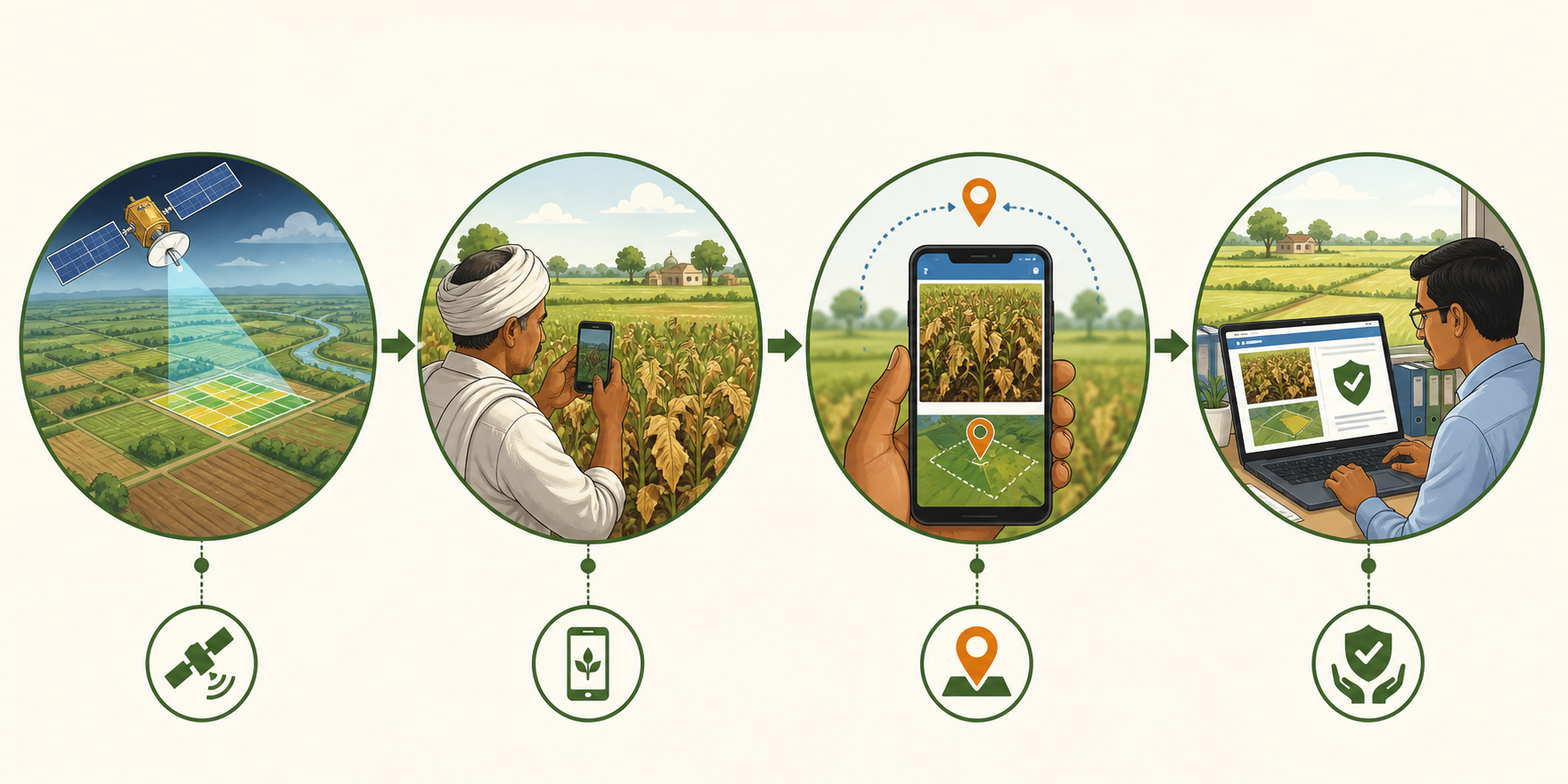
The distinction matters because PMFBY covers different kinds of loss in different ways. Widespread yield loss is generally calculated for a notified insurance unit under an area approach. Localised calamities and specified post-harvest losses may require individual-farm intimation and assessment. A tool that improves the first calculation is not automatically the same tool a farmer uses to report the second.
What YES-TECH actually changes
YES-TECH stands for Yield Estimation System Based on Technology. It was introduced for paddy and wheat from Kharif 2023 and extended to soybean from Kharif 2024. The government’s stated direction is gradual migration from heavy dependence on physical Crop Cutting Experiments (CCEs) toward technology-assisted yield estimation.
That does not mean CCEs disappeared overnight. Under the national rollout described by the government, at least 30 percent weightage is assigned to the YES-TECH-derived yield and the balance can still come from the conventional system. Madhya Pradesh moved further and adopted fully technology-based yield estimation; other implementing states used a blended approach.
The models can use remote-sensing indices, weather information, soil-moisture data, crop-growth stages and related inputs. A Technology Implementation Partner runs the selected model under the supervision of a government-nominated mentor institution. The aim is a repeatable estimate that arrives on time and is less vulnerable to a few late, disputed or unrepresentative field experiments.
Government reporting says the seven states that implemented YES-TECH in Kharif 2023 completed claim calculation and payout using it without a reported stakeholder dispute. That is encouraging, but it is an implementation claim from the scheme administrator—not proof that every village-level estimate is perfect.
Why “satellite claim” is a misleading shortcut
For widespread yield loss, PMFBY is mainly an area-yield insurance scheme. The important comparison is between the actual yield estimated for the notified insurance unit and its threshold yield. If the actual yield falls below the threshold, eligible insured farmers in that unit can receive a calculated payout.
YES-TECH helps produce the yield number. It does not normally calculate whether one particular farmer’s half-acre plot lost exactly 37 percent. Satellite pixels, weather grids and crop models can reveal patterns across an area, but they cannot always separate mixed crops, tiny plots, cloud-obscured images, late sowing or a field whose records name the wrong crop.
This is the same scale problem discussed in our article on AI crop-yield prediction in India: a model can be useful for a district or insurance unit while still being too coarse to describe one smallholding perfectly.
Where CROPIC fits
CROPIC stands for Collection of Real-Time Observations and Photographs of Crops. It uses a mobile application to collect geotagged, time-stamped photographs from farmers and field coordinators. A sequence of images can help confirm that the insured crop is actually growing on the recorded plot, track crop health and document visible damage after a localised calamity.
The official design gives CROPIC three practical roles:
- Crop validation: checking the photographed crop against the crop recorded in the insurance data.
- Damage evidence: supporting assessment when hail, inundation, landslide, cloudburst or another notified localised peril affects a particular plot.
- Model support: providing field evidence that can validate or improve YES-TECH’s wider yield estimates.
A geotagged photograph is stronger evidence than an unverified phone photo because it records where and when the image was taken. But it is still evidence, not an automatic approval. Image quality, phone access, network availability, the timing of the photograph and correct linking to the policy record all matter.
The 72-hour rule matters more than the AI
For specified individual-farm events, the operational guidelines require the insured farmer to give immediate intimation—generally within 72 hours. The notice should identify the insured crop, the affected acreage and the loss. Official reporting channels include the insurer, the bank, local agriculture or district officials, the National Crop Insurance Portal or the central support system.
The PMFBY portal directs farmers to the Krishi Rakshak Portal and Helpline at 14447 for grievances and crop-loss reporting. The official PMFBY WhatsApp chatbot is available at 7065514447. Keep the policy or application number, acknowledgement, bank details, crop and plot information, and any geotagged photographs ready.
Do not assume that uploading a photograph somewhere—especially to an unofficial WhatsApp number—counts as valid claim intimation. Obtain a ticket, acknowledgement or other traceable record from the official channel you use.
What the WhatsApp chatbot can and cannot do
The chatbot lowers the first barrier: finding scheme information without navigating a complex portal. It can help a farmer locate PMFBY services and understand the next step through a familiar messaging interface.
What official descriptions do not establish is equally important. The chatbot is not presented as an insurance surveyor, a final grievance authority or a machine that independently sanctions money. A useful answer in WhatsApp does not override the policy record, the notified crop and area, the loss-reporting deadline or the insurer’s assessment process.
If the problem is an unresolved grievance, the operational framework provides escalation beyond the first helpline response. District-level grievance officers and committees are part of the formal route, followed where necessary by the state-level committee. Preserve every acknowledgement and screenshot so the issue can be traced.
What a farmer should do before any loss happens
- Verify the application. Check the farmer name, bank account, mobile number, crop, area, season and plot details. A technically accurate model cannot repair a policy that insured the wrong crop.
- Save proof. Keep the premium receipt, application or policy number and enrolment acknowledgement. Do not rely only on an SMS that may be deleted.
- Know the insurer and channels. Record the insurer’s contact, the PMFBY helpline 14447 and WhatsApp number 7065514447 before a storm or flood.
- Photograph intelligently. Capture the whole-field context and close damage, keep location enabled when the official app requests it, and take more than one clear image.
- Report quickly. For an individual-farm event, treat 72 hours as a hard operational deadline. Do not wait for a village survey team to notice the damage.
- Keep the ticket. Ask for a complaint or intimation number and follow the status rather than assuming the submission completed.
So is PMFBY becoming faster and fairer?
Potentially, yes—but the gain is in better evidence, not magic automation.
YES-TECH can reduce dependence on thousands of manual yield experiments and create a consistent area-level estimate. CROPIC can put dated, location-linked field evidence into a process that previously relied heavily on paper and delayed visits. WhatsApp can make support easier to reach. Together, they can narrow some of the information gaps that make farmers distrust crop insurance.
The remaining weak points are familiar: incorrect enrolment data, patchy implementation between states, poor connectivity, model error on small or mixed plots, delayed subsidy or yield data, and grievance systems that still require persistence. Technology makes the claim trail more visible; it does not remove every institution between a damaged crop and a bank payment.
The practical verdict is simple: use the digital tools, but keep your own evidence and follow the formal deadline. A satellite may help calculate the loss. Your receipt, correct crop record and timely intimation are still what connect that calculation to you.
Sources
- Press Information Bureau — Artificial Intelligence Transforming Indian Agriculture, 14 February 2026
- Press Information Bureau — Assessment of Crop Losses through Satellite, 11 February 2025
- Press Information Bureau — Objectives, Components and Functioning of CROPIC, 25 July 2025
- PMFBY — YES-TECH Manual 2023
- PMFBY — Revised Operational Guidelines
- PMFBY official portal — claim process, applications and support tools
- District Commissioner, Udalguri — official crop-loss reporting helplines, June 2025
